Day: December 16, 2019

  • ASEAN Studies Center Was Asked to Explore South China Sea Dispute

    ASEAN Studies Center Was Asked to Explore South China Sea Dispute

    Director General of Asean Cooperation in Foreign Affairs Ministry, Jose Antonio Morato Tavares, said currently there are 58 Asean Studies Centers in Indonesian universities that conduct research, consultancy, and publication to promote Asean cooperation.

    He said that these centers of studies would be grouped into divisions such as on politics and security, economy, and socio-culture. They are expected to identify specific issues to explore. “Each is expected to set up a program on research, consultancy, and publications to promote Asean cooperation,” he said.

    He said the government would expect assistance from these Asean studies centers to conduct studies and research into foreign policy making, such as Indonesia’s stance on maritime borders, or land territory in the South China Sea, although there is already an international rule to comply with. “I think there’s still some gap or unregulated aspects that can be addressed here,” he said.

    He added the centers would also explore studies in international laws that need documents to complete. So far, there has not been much research done into it. “Up to now, there is no research on it, if there’s one, we can bring it on our South China Sea negotiations,” he said.

    Besides, the centers would study the potential of free trade market in Asean and Indonesia’s stance to play a more maximal role.

    Maritime Law Geodesy expert of UGM, I Made Andi Arsana, Ph.D, said the dispute on maritime borders and land territory of South China Sea has not yet been resolved. There are around 200 islands being on dispute. “About 200 islands are disputed in South China Sea regarding ownership,” he said.

    Countries like Vietnam, Malaysia, Brunei Darussalam, the Philippines, and China have made territorial claims. He said the certainty of the ownership would determine the Indonesia’s maritime borders. Even if Indonesia has no interest in these islands, Indonesia needs to pay attention to its maritime borders around the South China Sea. “Indonesia has the right of its sea territory, for example, on North Natuna and the 200 miles border of the outermost islands that may overlap with those of other countries,” he said.

    Source: https://ugm.ac.id/id/berita/18857-pusat-studi-asean-diminta-kaji-soal-sengketa-laut-cina-selatan


  • UGM Develops Innovation to Calculate Greenhouse Gas Emissions in Agriculture

    UGM Develops Innovation to Calculate Greenhouse Gas Emissions in Agriculture

    The technology was developed by lecturer of the Department of Agricultural and Biosystem Engineering, Bayu Dwi Apri Nugroho, Ph.D. This technology can calculate methane (CH4), carbon dioxide (CO2), and ammonium (NH4) levels produced in agricultural lands.

    Bayu said that so far the development of smart agriculture has always been oriented to precision farming or on-farm. Meanwhile, data obtained from sensors installed on agricultural land can actually be used to calculate other information outside of on-farm, including calculating greenhouse gas emissions.

    “So far, the calculation of greenhouse gas emissions on agricultural land has been done manually and estimates have been based on secondary data such as the types of variety and fertilizer, and then referenced to the guidelines from the Intergovernmental Panel on Climate Change (IPCC). But in reality, produced carbon emissions may exceed the prediction,” he said to reporters during a press conference done in Fortakgama room UGM on Monday (16/12).

    The agriculture sector, said Bayu, is one of the contributors to greenhouse gases. Greenhouse gas emissions contributed from the agricultural sector are around 24 percent and tend to increase from year to year. In the last 50 years there has been an increase in greenhouse gases from the agricultural sector by almost 100 percent. In 1961 this sector contributed greenhouse gases of 2.7 billion tons of CO2 and experienced a significant increase in 2012 to 5.4 billion tons of CO2. The main sources of greenhouse gas emissions from the agricultural sector come from conventional agriculture which uses chemical fertilizers and excess irrigation, the use of unfermented fertilizers, and massive burning of straw on agricultural land.

    Agricultural sector, according to Bayu, is one of the contributors to greenhouse gas emissions, or around 24 percent which is increasing from year to year. In the last 50 years there has been an increase in greenhouse gases from the agricultural sector by almost 100 percent. In 1961 this sector contributed greenhouse gases of 2.7 billion tons of CO2 and experienced a significant increase in 2012 to 5.4 billion tons of CO2. The main sources of greenhouse gas emissions from the agricultural sector come from conventional agriculture which implements chemical fertilizers and excess irrigation, unfermented fertilizers, and massive burning of straw on agricultural land.

    Seeing this condition, Bayu made a calculation by using the data from sensors in real time and updates, such as data related to climate, ground parameters, and plant growth. These data can be used to evaluate irrigation systems and calculate the concentrations of greenhouse gas emissions.

    Through this technology data can then be obtained to calculate the emission from the telemetry. Furthermore, it is processed with an artificial neural network model (ANN) to reduce the emission value in the land.

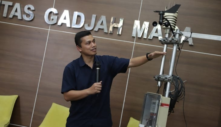
    This technology is built with 5 sensors in the field monitoring system (FMS), namely pyranometer, anemometer, humidity and temperature, rain, and soil humidity (including temperature and electrical conductivity of the ground). It is equipped with Em50 data logger to store the data. There is also a telemetry that functions to send data from the data logger to an automatic server every day using a modem from telecommunication providers. A camera is also installed to monitor rice and a solar panel to generate power.

    Bayu said the technology works when all sensors are connected to the data logger. Measurement is done automatically every 30 minutes and data will be directly stored. A field router will retrieve the data every day and send it to the server via GSM internet network. The field router will also send photos of the location once a day.

    “Users can access all data in the form of numerical data, graphics or images or photos through an already developed website,” he said.

    This innovation was developed since 2016 and has been piloted at the SRI rice cultivation demonstration plot in Kupang District, NTT in collaboration with the Indonesia Climate Change Trust Fund / ICCTF BAPPENAS. Next in the 2018 period applied in East Sumba Regency, NTT and the development of FMS in the demonstration plots in Banjarnegara and Purbalingga with funding from the Higher Education Research Consortium, RISTEKDIKTI.

    This innovation has been developed since 2016 and piloted at the SRI rice cultivation demonstration plot in Kupang District, East Nusa Tenggara, in collaboration with Indonesia Climate Change Trust Fund/ICCTF BAPPENAS. In 2018 this technology was applied in East Sumba and FMS in demonstration plots in Banjarnegara and Purbalingga with funding from the Higher Education Research Consortium, RISTEKDIKTI.

    The development of IoT smart farming is expected to support the low carbon building in the country, especially in agriculture. Moreover, the government has stipulated that provinces ought to report their greenhouse gas emission calculations.

    The development of IoT-based smart agriculture is expected to support low-carbon building in the country, especially in agriculture. Moreover, the government has stipulated that provinces ought to report their greenhouse gas emission calculations.

    “Hopefully, this technology helps achieve environmentally friendly agriculture with precision farming that puts forth efficiency in using information to make decisions,” he said.

    He also hoped it would benefit farmers by making it easier for them to carry out farming activities and increasing agricultural productivity through the use of a planting calendar and the right cropping patterns as well as lower production costs. (UGM Public Relations / Ika; photo: Firsto)

    Source: https://ugm.ac.id/id/berita/18856-ugm-kembangkan-inovasi-penghitung-emisi-gas-rumah-kaca-dari-lahan-pertanian

  • Wonder, an App for Handling Violence against Women and Children

    Wonder, an App for Handling Violence against Women and Children

    Women and children in Indonesia are vulnerable to violence. Indonesia is listed among the top ten countries most unsafe for women and children. According to surveys by Thomson Reuters Foundation in 2018 Indonesia ranked second after India in Asia Pacific.

    The reason could be lack of response to violence against women and children and lack of community participation in the case that is still considered to be taboo. 

    To address these problems, an application, Wonder, was designed for two years. It was launched at Universitas Gadjah Mada (UGM) in Grha Sabha Pramana hall on Friday (13/12). Rector of UGM, Prof. Ir. Panut Mulyono, M.Eng., D.Eng., IPU, ASEAN Eng, Expert Staff to Social Affairs Ministry, Harry Z. Soeratin, Deputy Minister of Culture, Indra Gunawan, SKM., MA., and activists attended the launching.

    “We continue to try our best to prevent these cases. Currently, UGM is in the process of issuing special chancellor regulations regarding the handling of sexual abuse. The current regulation is being reviewed by the academic senate and hopefully in the near future we can publish it, “said the Chancellor.

    UGM is now implementing Ethical Management and Strengthening Integrity Program that emphasizes all academics of UGM to strengthen ethics, particularly in problems related to women. He agreed that quick response is required to protect women and children from abuse. Thus, the use of information technology will be beneficial.

    “I hope that Wonder will be helpful in reducing cases of abuse against women and children,” he said.

    Indra Gunawan thinks that Wonder is a great application for women and children in Indonesia. Wonder will help them take action before violence occurs. Although it was launched in Yogyakarta, he hopes this application will continue to be developed throughout Indonesia. He said that the app is useful during disasters, too. 

    Wonder is a quick and emergency relief application for victims of violence, developed by Yayasan Sebar Inspirasi Indonesia (YSII) with the support from Australia lndonesia Partnership for Justice 2 (AIPJ 2), Komnas Perempuan, and UGM.

    This application is used by the general public as well as registered volunteers. During an emergency situation, victims of violence can use “Wonder” to get help from the volunteers more easily. The volunteers in the application have been verified and trained by partner agemcy “Wonder Indonesia”.

    During an emergency, the victim can click the rescue button in the app. If possible, additional messages can be added. Volunteers who have registered within a radius of 3 kilometers, 5 kilometers and 10 kilometers from the victim’s location will receive a notification.

    There are three features in the app. First, rescue, which is an emergency service, provided to victims who need immediate rescue or evacuation. Second, shelters given to victims who experience distress and require an emergency shelter. Third, assistance or a service intended to help victims in mediation or legal processes.

    “This app enables people in times of emergency to reach the registered volunteers who have basic relevant skills,” said Executive Director of YSII, Atika.

    Atika added each of the volunteers ought to be affiliated to a registered voluntary organisation in Yogyakarta. Currently, around 40 organizations in the city have become partners of the service.

    Source: https://ugm.ac.id/id/berita/18845-wonder-aplikasi-untuk-tangani-kekerasan-perempuan-dan-ana